Credit: Conuco/BID
Putting themselves on the map: These citizens charted how their city moves
December 2, 2020 | By Amy KoverAnyone from Santiago de los Caballeros knows about the conchos. They are shared taxis that travel over 30 different routes throughout the Dominican Republic, carrying as many as six passengers at a time. It’s how 65% of Santiago’s 1.2 million residents get where they need to go every day.
While mass transit usually conjures up visions of sprawling, municipally run networks such as the London Tube or the New York City subway, most cities — particularly in Latin America, Africa and South Asia — rely on less formal systems, such as conchos, powered by entrepreneurial drivers who operate taxis, vans or buses to provide viable options for people with lower incomes and those in underserved neighborhoods.
The systems have worked well for years, with one significant caveat: No one knows exactly when a concho will show up. There’s no central map to check, no phone number to call, no website to visit. There are no official stops, and riders can ask the drivers to drop them off anywhere. That means employees must reserve hours of extra time to get to work. Some people cannot accept jobs that are too far away. Women cannot go out freely without worrying about their personal safety.

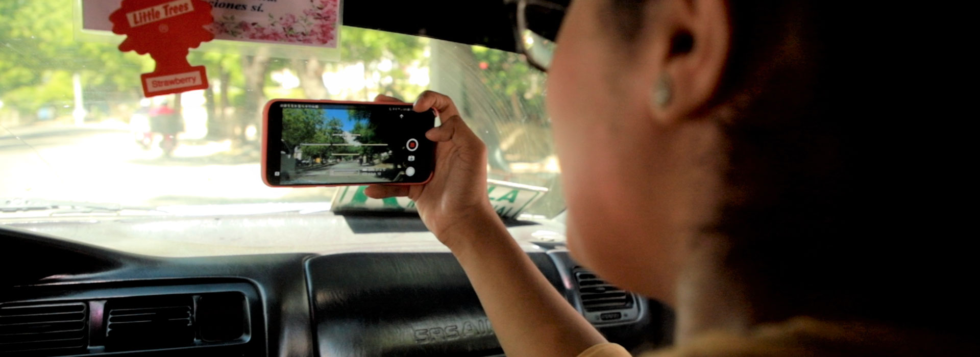
A volunteer with the DATUM initiative uses her phone and a mapping app to chart the less formal transit routes of Santiago de los Caballeros. (Conuco/BID)
Now there is a way to wipe this confusion off the map and make travel more reliable, accessible and safe. By using data collected at street level by the people who use these systems, these informal routes and schedules can be transformed into easy-to-read maps that offer more certainty, stability and safety for riders, help the city function more efficiently as a whole, and extend the benefits of the digital economy to more people.
A consortium that includes the World Resources Institute Mexico, the Mastercard Center for Inclusive Growth, the Inter-American Development Bank, Massachusetts Institute of Technology, and Columbia University built this platform, called Datos Abiertos de Transporte Urbano y Movilidad (Open Urban Transport and Mobility Data), or DATUM, and invited the people of Santiago and the Rockefeller Foundation’s 100 Resilient Cities network to work together to realize this vision.
First, the DATUM team connected with the city’s key organizations, including Santiago transportation authorities, the concho unions, three universities, a women’s advocacy group and another organization for the blind. “It’s kind of like conducting an orchestra, where you make sure community groups and volunteers are all working together,” says Luz Gomez, director of Latin America and Caribbean initiatives for the Center for Inclusive Growth.
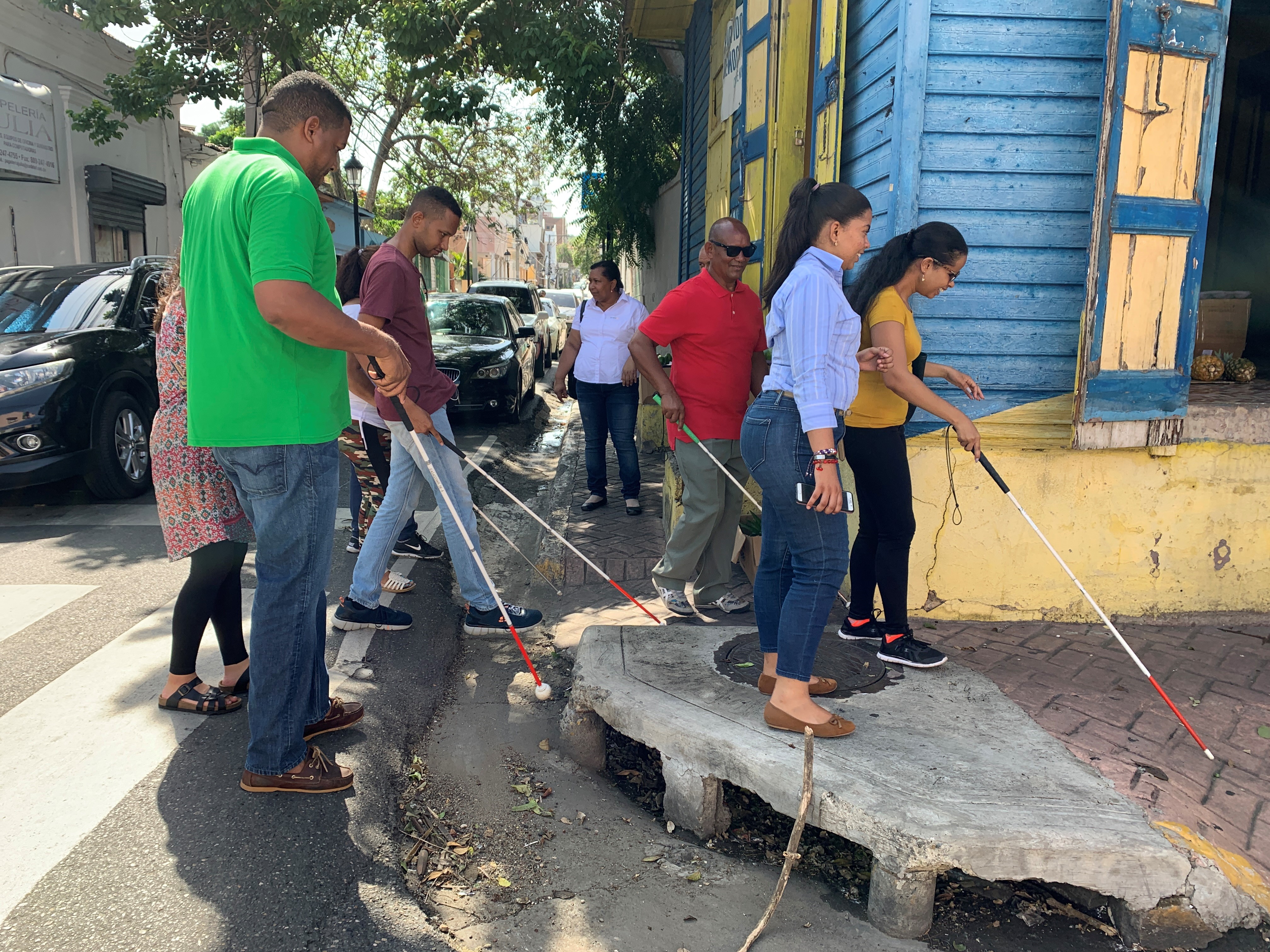
Volunteers with visual disabilities evaluate a neighborhood where a school for the blind is located to identify transportation accessibility challenges. (Natalia Coachman/IDB)
Government officials directed the team where to gather data, while the unions encouraged concho drivers to cooperate with the initiative. Then 30 university student volunteers toured 54 routes in the city and six intercity routes, gathering geo-referenced data on a mobile app called MapMap. Similarly, a group of visually impaired people and another group of women tested the routes to identify accessibility issues and safety concerns.
“As a resident of Santiago, I’ve had to transport myself from one end of the city to another on public transportation and honestly sometimes I’ve gotten lost,” says Cesar Ballast, a student at Universidad Autónoma de Santo Domingo. “I didn’t know where to catch the bus or the exact route to get there and that’s why I was interested in this project.”
Once the students captured the intricate, overlapping routes and schedules of the concho routes, the team turned its attention to designing an easy-to-follow map. “Visualization allows us to translate the complexity of data, and the insights we gain from it, to the average person,” says Sarah Williams, director of MIT’s Civic Data Design Lab and part of the DATUM team, who built off her work mapping informal routes in Nairobi, Kenya. “Maps are effective because they can communicate something in a second that might take longer through text or words.”
Then DATUM designers developed a single-page representative transit map like those plastered throughout New York, London and Tokyo. They invited participating community members to review it, making sure the routes were clear and location names correct.
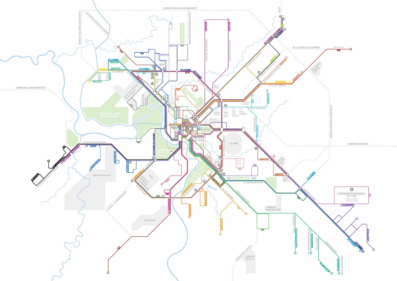
Following the community mapping effort, the DATUM team developed the first transit map for the city.
Then the team uploaded its data points to Google Maps, and now anyone in Santiago can find their bus route using the Google Maps app. The team also printed about 10,000 copies of the map for those who don’t have access to the internet. They had also inadvertently enlisted a team of enthusiastic influencers: “The students told all their friends about our map,” says David Escalante, transportation planning and operations manager for WRI Mexico. “It was getting kind of popular.”
The pandemic prevented the team from returning to Santiago to formally study the map’s impact, but policymakers can now work on improving potentially dangerous areas around the city based on data provided by DATUM. And thanks to DATUM, Santiago de los Caballeros became the first city in the Caribbean where Google Maps could provide public transport information.
“This project is a great example of how open data and knowledge can lead to inclusive urban development,” says Patricio Zambrano-Barragan of IDB’s Housing and Urban Development Division. “We hope this data can be shared and used by as many people as possible, especially citizens in Santiago.”
Across Latin America, cities are participating in or expressing interest in creating their own community data mapping programs, including Brasília, Brazil; Mexico City and Veracruz in Mexico; and Bogotá and Cartagena in Colombia. “Eventually this could push the economy forward,” Williams says. “It tells cities how to help people, even those in underserved neighborhoods, get to their jobs more safely and reliably. Cities did not have answers to those questions before.”
 Newsroom